Drones are dominating the battlefield in the Ukraine conflict – Copyright POOL/AFP Hagen Hopkins
AgEagle is a global technology innovator focused on enhancing situational awareness. The company provides customer-centric, advanced robotics solutions, beginning with autonomous drones that are high-value and solve mission-critical problems.
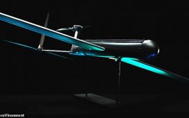
AgEagle’s professional fixed-wing drones, high-resolution drone sensors and intelligent drone software solutions are an efficient and a safe way to plan, capture, and process accurate aerial data.
To discovery more about the operation and the technology, Digital Journal spoke with Bill Irby, CEO of AgEagle Aerial Systems, Inc.
Digital Journal: Can you provide a brief background on AgEagle?
Bill Irby: AgEagle was initially started by a farmer and drone hobbyist in 2009. The founder began to apply his hand-crafted drone for use in agriculture analysis and turned it into a private enterprise starting in 2010. By identifying a key need in the agriculture space, AgEagle’s first solutions were born. It quickly became clear that there were many other industries that could benefit from similar solutions, like defense, public safety, public utilities, and environmental conservation, among others.
After years of successfully operating privately, the company went public in 2018 to access the market and open up new funding streams, raising capital for our operations and expansion. This culminated in the extension of our footprint into other technology businesses in 2021.
Today, AgEagle operates with a key focus on providing customer-centric situational awareness that is high value-add and solves mission-critical problems.
DJ: How does AgEagle enhance situational awareness?
Irby: AgEagle designs and builds drones, multi-spectral cameras, and integrated control software. The systems focus on optical identification and analysis for all missions, then they extract the data over a remote communications link to the pilot or other users. Our high-performance fixed-wing mapping drones like the eBee X, eBee VISION, and eBee TAC are autonomous, safe, ultra-light, and easy-to-use, while having both National Defense Authorization Act (NDAA) and European Union Aviation Safety Agency (EASA) compliance. Any company that is interested in improving their situational awareness through aerial data should be interested in our solutions as a cost-effective, efficient, and safe way to capture and analyze accurate aerial data.
DJ: What industries do you serve and who are some of your customers?
Irby: Our clients have grown from their beginnings in agriculture to include civil and commercial uses such as oil and gas pipeline monitoring, infrastructure inspection, mapping, and environmental monitoring all the way to the defense and public safety industries with things like security monitoring, law enforcement support, and military operations. As a company focused on situational awareness, we believe we can help any company that is looking to take to the air to learn more about a given situation.
AgEagle’s current clientele includes defense organizations like the Army Corps of Engineers, the U.S. Marine Corps, and the U.S. Customs & Border Protection, major agricultural and energy firms such as Cargill and Nutrien, and energy firms like Exelon.
DJ: Can you discuss your recent sales to the French Army and to a UAE distributor? What is the importance of these sales?
Irby: These two sales are incredibly important to the proof-of-concept for our business focus as our largest sales to date. They represent a major turning point in AgEagle’s history, with a strategic pivot to support allied defense and security in addition to our historical customer sets like agriculture and environmental monitoring. Our recent entry into these areas is the result of a two and a half year development effort, working directly with several end-user customers to develop and adapt our systems for best-use in scenarios of most interest to them. This is a significant strategic shift for AgEagle and we’re excited to showcase what our solutions can do for these customers.
DJ: What type of legislation has impacted the drone industry in the past year?
Irby: On the legislative front, we continue to monitor a rapidly changing environment. In December 2023, the American Security Drone Act (ASDA) passed as part of the NDAA. Under ASDA, the federal government cannot purchase drones from China and other places that are seen as threats. From the Defense Innovation Unit employing processes to approve “blue UAS” listed units that can be bought by the Department of Defense as pre-approved systems, to the Federal Aviation Administration making modifications in policy across the nation, many of the other interesting and rapid changes are happening state-by-state. States decide policies for use in state-controlled organization and by users in state-controlled areas.
Organizations such as the Association for Uncrewed Vehicle Systems International (AUVSI) work diligently to ensure the best-use of policy for safe-use and expansion of the drone industry. We continue to monitor these developments as they happen and believe our fixed-wing solutions are some of the best and easiest-to-use on the market that are federally and state compliant.
DJ: Where do you expect the drone industry to go in the next five years?
Irby: In the next five years, the drone industry will see rapid expansion of use for local governments and businesses. As drones expand beyond the largest players and accessibility into the technology continues to widen, we will see greater adoption among those who have a need that can be simplified with aerial solution.
In the larger systems, “Advanced Air Mobility” will grow quickly, with autonomously controlled human-carrying “air taxis” becoming reality. We’re excited about the future of this industry and believe we are well-positioned to capitalize on the growing interest in aerial situational awareness.


